Wave Recorders
RADAC level, tide and wave monitoring
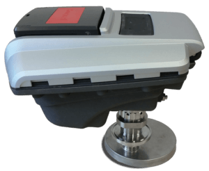
WaveGuide radar
The WaveGuide radar measures the distance to the water surface 10 times per second. Proven is that in all wind and wave conditions the standard deviation for water level is only 1 cm. The radar technology is based on Honeywell Enraf core technology used for tank gauging. Mounted high above the water and without any moving parts there is no need for preventive maintenance or cleaning. (Re-)calibration is never required due to the long-term stable zero reference. The system is compact, robust and easy to install. It is suited to accurately measure wave heights and tides, up to the most extreme conditions.
The radar comes in two versions: the Compact version and the ATEX certified version.
The system is based on a low power processor, does not have any moving parts and can synchronise to UTC-time.Data can be distributed via ethernet. The user can configure the data sets (raw data, spectra, parameters) using the subscription interface. Radio, gsm, gprs and satellite modems are supported. Raw data, spectra and parameters can be requested and are presented within the web-browser.
DATASHEET:
https://radac.nl/docs/Brochure_WaveGuide.pdf
WaveGuide direction
With an array of three radars the elevations of the sea surface is measured at three positions. Knowing the slopes and the phase relations, the directional spectrum can be accurately calculated. Radac is the only company that brings this technology to the market.
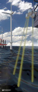
The directional system consists of three downward-pointing radars. Depending on the set-up, all are perpendicularly pointed downwards or one/two are tilted. We recommend the one-point array (3) for most applications. All three radars are mounted in the one-point frame. One radar points downwards, and the other two are tilted under an angle of 15 degrees. See visualisation below.
Wavelengths are optimally monitored with 3 to 30 times the array size. For example, if the wave radar system is mounted at a 18.6 m height, the footprints of the radars are five meters apart. So the optimal measurements are between 15m and 150m wave length (3-10 sec period).
Other, less used options are the three-point array (1) with three downward pointing radars and the line array (2) with one radar is tilted. See image below.

DATASHEET:
WaveGuide direction Height & Tide
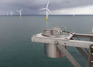
The WaveGuide Height & Tide accurately measures wave height, wave period and tide.
Mounted high above the water and without any moving parts there is no need for preventive maintenance or cleaning. (Re-) calibration is never required due to long term stable zero reference and constant sensitivity. The system is compact, robust and easy to install. It is equipped to measure wave heights and tides accurately, even in the most extreme conditions.
Products
- WaveGuide Height & Tide
- WaveGuide Height & Tide Ex certified
Benefits
- No maintenance
- Easy installation
- Suitable for all weather conditions
- Low power consumption device
- Explosion proof certified
- Excellent price/performance ratio
Key specs
- Wave height
- Wave period
- Water level / tide
Applications
- Offshore oil and gas platforms
- Offshore wind parks and platforms
- Harbours and coast
- Input to Met-Ocean systems
DATASHEET:
https://radac.nl/docs/Radac_productsheet_WG5_Height&Tide.pdf
WaveGuide Onboard
The WaveGuide Onboard installation compensates for the vertical motions of the ship, so it measures the waves the ship actually has to endure.
It consists of a sensor unit on the bow of the ship and a server. The sensor unit contains a WaveGuide Radar to measure distance to the water surface. The distances measured have to compensate for the vertical motions of the radar itself. Hence, a motion sensor is incorporated into the sensor unit. The compensated radar signal is processed in the same way as the standard WaveGuide mounted on a fixed platform.
GPS for synchronisation with UTC time and for position information is optional.
Using the available “Wave and Tide Processing Software” raw data, spectra and parameters can be requested and presented on the web browser. All data or a selection thereof can then be stored in a data logger.
DATASHEET:
WaveGuide Water Level
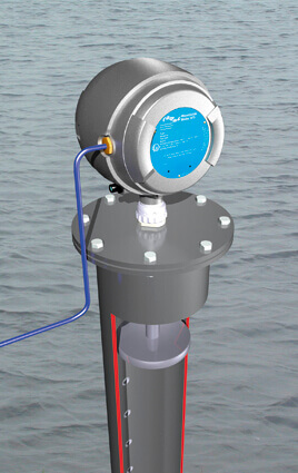
In more protected areas, the motions of the water’s surface can be measured in two ways: using a WaveGuide Height & Tide or a WaveGuide Water Level mounted on top of a pipe (stilling well version).
With the WaveGuide Height & Tide the water level is measured at the point where it’s mounted (bridge, pool and so on). The WaveGuide Water Level version measures the water level in a pipe. This pipe can be left completely open, as there is no need for a small water entrance. Cleaning, as a result of marine growth is hardly required. The rapid motions of the water surface are filtered in the WaveGuide server, allowing measurements of faster phenomena like seiches (harbour oscillations).
With the available “Tide Processing Software” raw data and parameters can be requested and displayed on a computer’s web browser. All data or a selection thereof can be stored in a data logger. With a special stilling well antenna 150, 200, 250 and 300 mm pipe diameters are supported. Periods of 10 seconds and 1, 5 and 10 minutes are readily available (others on request).
Products
- WaveGuide Height & Tide
- WaveGuide Water Level
Benefits
- No maintenance
- Reliable, durable, accurate
- Suitable for all weather conditions
- Low power consumption device, suitable for solar energy supply
Key specs
- Phenomena periods 0-0.5 Hz
- Accuracy water level <10 mm
- Processing period 10s, 1, 5 and 10 minutes
Applications
- Harbours and ports
- Rivers
- Bridge clearance
- Lakes, Dams
